
CURRENT BRIEFING
9.28.23 at 6:30 pm
Heavy rainfall may lead to considerable and significant flash flooding
and river flooding across portions of northern and central New Jersey.
The heaviest rainfall amounts will be highly localized, not widespread.
Minor coastal flooding is expected along the Atlantic coasts of New
Jersey and Delaware, Delaware Bay, and the tidal Delaware River
with each high tide through at least Saturday.
Life-threatening rip currents and rough surf along all New Jersey
and Delaware beaches into the weekend. Areas of beach erosion are
possible.
Hazardous marine conditions are expected to persist through the
weekend.
PAST BRIEFINGS
9.28.23
8 AM notice
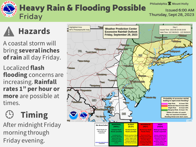
Another coastal storm is slated to impact the region beginning late tonight and continuing through Friday, bringing the potential for heavy rainfall and localized flash flooding. Here are your key messages:
Heavy showers and possible thunderstorms will arrive after midnight tonight and may continue into the afternoon and evening hours Friday.
Total rainfall amounts of 1 to 3 inches are currently forecast with locally higher amounts possible. Exact timing of the onset of heaviest rainfall remains uncertain.
A more concentrated area of heavy rain could develop at some point and result in rainfall rates 1 inch per hour or more at times. At this time, there is high uncertainty where this concentrated area of heavy rain will set up. The risk for flash flooding (at least 15%) will be a concern in this area. Please see the latest Excessive Rainfall Outlook from the Weather Prediction Center attached.
Heavy downpours may impact travel much of the day Friday, particularly during the morning rush hour.
Minor coastal flooding is expected to continue through Friday night. A High Risk for rip currents will remain through at least Friday.